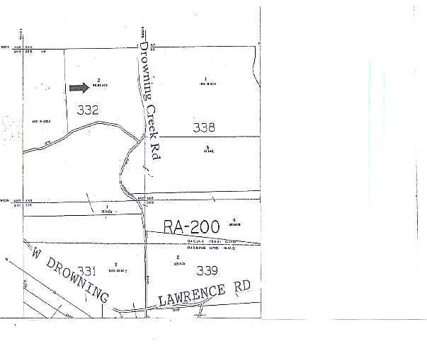
Property Record
1421 Drowning Creek Rd, Dacula, GA 30019
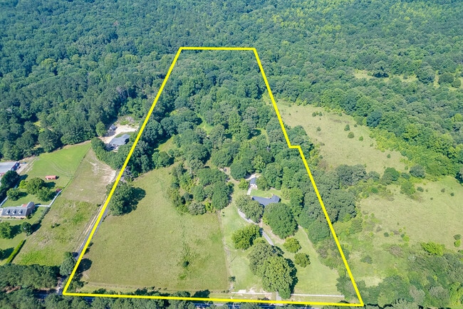
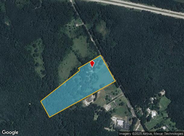
This Property Is For Sale
Property Detail
1421 Drowning Creek Rd
5-330-002
Drowning Creek
Sfr
DROWNING CREEK RD
A
Gwinnett
13135C0078G
Georgia
2025
17.63 AC
2025
Lawrenceville/Lilburn
050623
Atlanta
2,697 SF
Atlanta-Sandy Springs-Roswell, GA
NEARBY LISTINGS FOR SALE OR LEASE
DEMOGRAPHICS near 1421 Drowning Creek Rd
1 mile
3 mile
5 mile
2024 Total Population
1,389
20,507
73,631
2029 Population
1,456
22,047
79,270
Pop Growth 2024-2029
+ 4.82%
+ 7.51%
+ 7.66%
Average Age
36
37
37
2024 Total Households
405
6,431
22,557
HH Growth 2024-2029
+ 4.94%
+ 7.85%
+ 7.95%
Median Household Inc
$79,605
$93,341
$97,125
Avg Household Size
3.40
3.20
3.20
2024 Avg HH Vehicles
2.00
2.00
2.00
Median Home Value
$490,322
$399,317
$387,088
Median Year Built
2010
2002
2003
Nearby Places
Map Layers
Map Styles
 Street
 Aerial
Transit
 Traffic
 Biking
Places
Listings with unknown addresses are not visible on the map
- Restaurants
- Banks
- Shops
- Fitness
- Groceries
Nearby Properties
Address
Land Use
TOTAL SIZE
Lot Size
Zoning
Address
Land Use
TOTAL SIZE
Lot Size
Zoning
637.87 AC
RA200
Address
Land Use
TOTAL SIZE
Lot Size
Zoning
420,876 SF
26.84 AC
M-2
Address
Land Use
TOTAL SIZE
Lot Size
Zoning
164,877 SF
34.89 AC
C1
Address
Land Use
TOTAL SIZE
Lot Size
Zoning
160,446 SF
12 AC
GOV
Address
Land Use
TOTAL SIZE
Lot Size
Zoning
143,845 SF
31.36 AC
RA200
Address
Land Use
TOTAL SIZE
Lot Size
Zoning
305,327 SF
22.05 AC
M-2
Address
Land Use
TOTAL SIZE
Lot Size
Zoning
301,200 SF
39.18 AC
M-2
Address
Land Use
TOTAL SIZE
Lot Size
Zoning
47,141 SF
8.29 AC
AG
Address
Land Use
TOTAL SIZE
Lot Size
Zoning
231,285 SF
34.50 AC
M-2
Address
Land Use
TOTAL SIZE
Lot Size
Zoning
70,345 SF
10.51 AC
PMUD
Address
Land Use
TOTAL SIZE
Lot Size
Zoning
167,580 SF
21.82 AC
M-2
Address
Land Use
TOTAL SIZE
Lot Size
Zoning
183,060 SF
17.90 AC
M-2
Address
Land Use
TOTAL SIZE
Lot Size
Zoning
327.79 AC
R100
Address
Land Use
TOTAL SIZE
Lot Size
Zoning
89,520 SF
13.99 AC
M-2
Address
Land Use
TOTAL SIZE
Lot Size
Zoning
23,546 SF
24.55 AC
RA200
Address
Land Use
TOTAL SIZE
Lot Size
Zoning
93,204 SF
4.78 AC
C3
Address
Land Use
TOTAL SIZE
Lot Size
Zoning
20,660 SF
10.94 AC
RA200
Address
Land Use
TOTAL SIZE
Lot Size
Zoning
84,363 SF
20.81 AC
C-2
Address
Land Use
TOTAL SIZE
Lot Size
Zoning
15,808 SF
16.43 AC
RA200
Address
Land Use
TOTAL SIZE
Lot Size
Zoning
12,896 SF
9.76 AC
C2
Address
Land Use
TOTAL SIZE
Lot Size
Zoning
16,384 SF
5.10 AC
RA200
Address
Land Use
TOTAL SIZE
Lot Size
Zoning
363.92 AC
RA200
Address
Land Use
TOTAL SIZE
Lot Size
Zoning
212.21 AC
RA200
Address
Land Use
TOTAL SIZE
Lot Size
Zoning
151.81 AC
Address
Land Use
TOTAL SIZE
Lot Size
Zoning
4,416 SF
1.14 AC
PMUD
Address
Land Use
TOTAL SIZE
Lot Size
Zoning
15,169 SF
5.71 AC
M1
Address
Land Use
TOTAL SIZE
Lot Size
Zoning
1,036 SF
120.72 AC
C1
Address
Land Use
TOTAL SIZE
Lot Size
Zoning
107.74 AC
RA200
Address
Land Use
TOTAL SIZE
Lot Size
Zoning
22.14 AC
PMUD
Address
Land Use
TOTAL SIZE
Lot Size
Zoning
16,568 SF
4.01 AC
M1
The World's #1 Commercial Real Estate Marketplace
Connect with us
© 2026 CoStar Group
The information above has been obtained from sources believed reliable. While we do not doubt its accuracy we have not verified it and make no guarantee, warranty or representation about it. It is your responsibility to independently confirm its accuracy and completeness. Any projections, opinions, assumptions, or estimates used are for example only and do not represent the current or future performance of the property. The value of this transaction to you depends on tax and other factors which should be evaluated by your tax, financial, and legal advisors. You and your advisors should conduct a careful, independent investigation of the property to determine to your satisfaction the suitability of the property for your needs.